GeoLogic Mapping C

User avatar
elephantower
Member
Member
Posts: 97
Joined: November 23rd, 2013, 6:36 pm
Division: C
State: AZ
Has thanked: 0
Been thanked: 0

Re: GeoLogic Mapping C

Post by elephantower »

Image
The fault featured has a heave of 12 m and a throw of 10 m. There is a lamina of unobtainium along the shale-sandstone paraconformity. A mining company wants to dig a vertical shaft at the red dot to extract the unobtainium. Assuming the lamina is of negligible thickness (it is unobtainium after all :P ), how deep will the company have to dig to reach it?
PS: The paraconformity should be perpendicular to the black line, and the acute angle between the fault and the lamina is 75 degrees.
Last edited by elephantower on April 2nd, 2015, 11:39 pm, edited 2 times in total.
[S/N]
N/A = didn't compete

2013:
Geologic Mapping: 1, 2
Designer Genes: 3, :(
Astronomy: N/A, :(
2014:
Geologic Mapping: 1, N/A
Protein Modelling: 1, N/A
It's About Time: 1, N/A
Forensics: 9, N/A
2015:
Geologic Mapping: 1, ?
Hydrogeology: 1, ?
It's About Time: 1, ?
Forensics: 10, ?
User avatar
elephantower
Member
Member
Posts: 97
Joined: November 23rd, 2013, 6:36 pm
Division: C
State: AZ
Has thanked: 0
Been thanked: 0

Re: GeoLogic Mapping C

Post by elephantower »

Nobody? :(
[S/N]
N/A = didn't compete

2013:
Geologic Mapping: 1, 2
Designer Genes: 3, :(
Astronomy: N/A, :(
2014:
Geologic Mapping: 1, N/A
Protein Modelling: 1, N/A
It's About Time: 1, N/A
Forensics: 9, N/A
2015:
Geologic Mapping: 1, ?
Hydrogeology: 1, ?
It's About Time: 1, ?
Forensics: 10, ?
User avatar
finagle29
Exalted Member
Exalted Member
Posts: 51
Joined: January 28th, 2013, 11:37 am
Division: Grad
State: PA
Has thanked: 0
Been thanked: 0

Re: GeoLogic Mapping C

Post by finagle29 »

since the red dot is 40 m in the direction of the strike, wouldn't this just be [math]\frac{40\textrm{ m}}{x}=\frac{\textrm{heave}}{\textrm{throw}}\Rightarrowx=33.3\textrm{ m}?[/math]
Bayard Rustin HS Alum

2013 Events: Thermo, Circuit Lab, Experiment, Robot Arm
2014 Events: Circuit Lab, Experiment, TPS, Mat Sci, Astro
2015 Events: Astro, Chem Lab, Compound Machines, Experiment, Time, TPS
2016 Events: Astro, Cell Bio, Chem Lab, Electric Vehicle, Time, Protein Modeling, Wind Power
User avatar
elephantower
Member
Member
Posts: 97
Joined: November 23rd, 2013, 6:36 pm
Division: C
State: AZ
Has thanked: 0
Been thanked: 0

Re: GeoLogic Mapping C

Post by elephantower »

finagle29 wrote:
since the red dot is 40 m in the direction of the strike, wouldn't this just be [math]\frac{40\textrm{ m}}{x}=\frac{\textrm{heave}}{\textrm{throw}}\Rightarrowx=33.3\textrm{ m}?[/math]
No, sorry
You mistook the lamina for the fault line-- the fault is running north-south through the center of the page.

EDIT: Re-read your answer. You recognized that the line between the lamina and the dot is parallel to the strike line, but heave and throw are measured along the dip (the whole point of the strike line is that it's level). Try drawing out the contour structures of the bed and fault.
[S/N]
N/A = didn't compete

2013:
Geologic Mapping: 1, 2
Designer Genes: 3, :(
Astronomy: N/A, :(
2014:
Geologic Mapping: 1, N/A
Protein Modelling: 1, N/A
It's About Time: 1, N/A
Forensics: 9, N/A
2015:
Geologic Mapping: 1, ?
Hydrogeology: 1, ?
It's About Time: 1, ?
Forensics: 10, ?
User avatar
silentsage
Member
Member
Posts: 88
Joined: December 22nd, 2011, 10:09 am
Division: C
State: PA
Has thanked: 0
Been thanked: 0

Re: GeoLogic Mapping C

Post by silentsage »

Assuming I set up this diagram right the depth is about 10.648m[attachment=0]geomapping.png[/attachment]
Attachments
geomapping.png
Road Scholar seems to depress everyone on my team who does it, but it's my favorite event...
I <3 DQIX and Squirtle
2013 RS National Champ
User avatar
elephantower
Member
Member
Posts: 97
Joined: November 23rd, 2013, 6:36 pm
Division: C
State: AZ
Has thanked: 0
Been thanked: 0

Re: GeoLogic Mapping C

Post by elephantower »

silentsage wrote:
Assuming I set up this diagram right the depth is about 10.648m[attachment=0]geomapping.png[/attachment]
I believe that's correct. With SciOly season over early this year, I haven't been frequenting the forums as much, sorry :(
Your turn!
[S/N]
N/A = didn't compete

2013:
Geologic Mapping: 1, 2
Designer Genes: 3, :(
Astronomy: N/A, :(
2014:
Geologic Mapping: 1, N/A
Protein Modelling: 1, N/A
It's About Time: 1, N/A
Forensics: 9, N/A
2015:
Geologic Mapping: 1, ?
Hydrogeology: 1, ?
It's About Time: 1, ?
Forensics: 10, ?
User avatar
silentsage
Member
Member
Posts: 88
Joined: December 22nd, 2011, 10:09 am
Division: C
State: PA
Has thanked: 0
Been thanked: 0

Re: GeoLogic Mapping C

Post by silentsage »

No problem at all, my season ended yesterday :( . I'm probably going to study geomapping all summer. Yay!

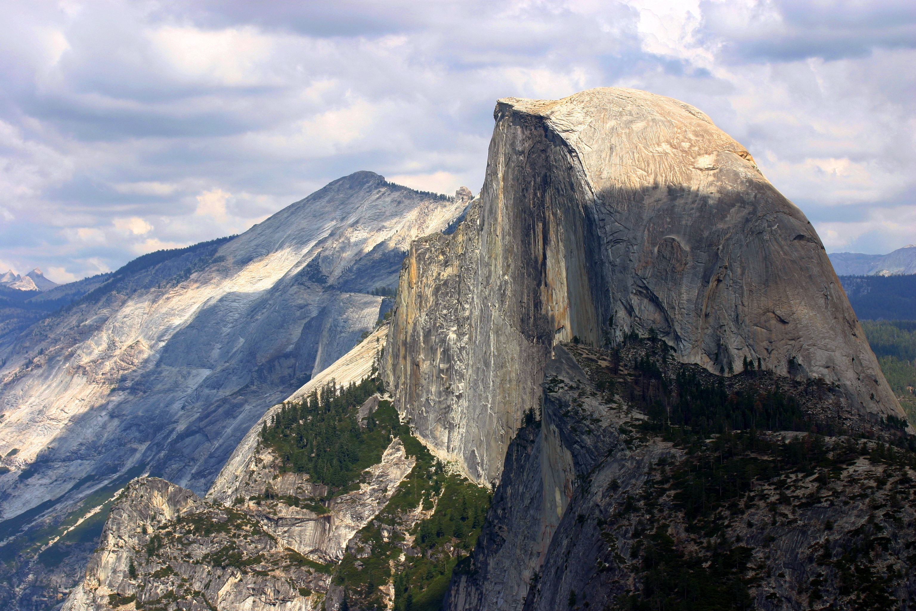
Anyway, here's the next question: What type of formations are El Capitan and Half-Dome in Yosemite (a single-word term), how did they form, and why are we able to see them now (think about the history of that area)? If you haven't heard of these, here are pictures: ImageImage
Road Scholar seems to depress everyone on my team who does it, but it's my favorite event...
I <3 DQIX and Squirtle
2013 RS National Champ
User avatar
boomvroomshroom
Member
Member
Posts: 189
Joined: February 19th, 2015, 5:10 pm
Division: C
State: CA
Has thanked: 0
Been thanked: 0

Re: GeoLogic Mapping C

Post by boomvroomshroom »

silentsage wrote:No problem at all, my season ended yesterday :( . I'm probably going to study geomapping all summer. Yay!

Anyway, here's the next question: What type of formations are El Capitan and Half-Dome in Yosemite (a single-word term), how did they form, and why are we able to see them now (think about the history of that area)? If you haven't heard of these, here are pictures:
[img]http://www.camerawest.com/cwblog/wp-content/uploads/2012/06/Photo-by-Margaret-Hara2.jpg[/img][img]http://upload.wikimedia.org/wikipedia/commons/2/25/Half_dome_yosemite_national_park.jpg[/img][/quote]

1. Plutons (wild guess - I have no idea what you're looking for exactly; sorry)
2. massive igneous intrusions that were then uplifted and eroded away to form their specific steep walls
3. Surrounding rock eroded away/area in general uplifted, exposing the rock
Chris_L
Member
Member
Posts: 75
Joined: December 11th, 2014, 10:26 pm
Division: Grad
State: CA
Has thanked: 0
Been thanked: 0

Re: GeoLogic Mapping C

Post by Chris_L »

1. Batholith 2. Igneous Intrusion that was uplifted. 3. Erosion from Merced River and other rivers in area caused gorge to form beneath Half Dome and El Cap, exposing the sides of these giant igneous intrustions.
"A wise man can learn more from a foolish question than a fool can learn from a wise answer." -Bruce Lee

When asked what his IQ was, Stephen Hawking said "I have no idea. People who boast about their IQ are losers"
User avatar
silentsage
Member
Member
Posts: 88
Joined: December 22nd, 2011, 10:09 am
Division: C
State: PA
Has thanked: 0
Been thanked: 0

Re: GeoLogic Mapping C

Post by silentsage »

Almost there, but I'll give it to you, Chris. Parts 1 and 2 are great, but the erosional process was glaciation--look at the shape of the valley.
Road Scholar seems to depress everyone on my team who does it, but it's my favorite event...
I <3 DQIX and Squirtle
2013 RS National Champ
Locked

Return to “2015 Question Marathons”

Who is online

Users browsing this forum: No registered users and 3 guests